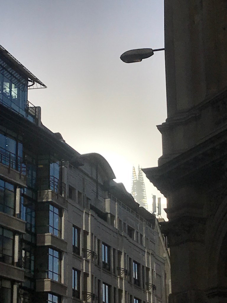
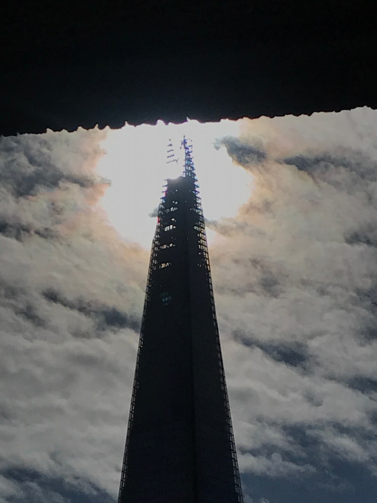
I didn’t expect anything different four days later. Here’s the narrow gap, goodness knows where the Sun is there. This was going to be a recurring problem with the Sun this low and the buildings so high.
I’d resigned myself to a winter not bothering. Despite vapid promises to save Christmas we locked down again and everyone fell into a pit of gloom, heavy food and heavier drinking. A few sunny days came and went with no hopeful strolls west, I checked the maps casually throughout on the off-chance of an angle, but otherwise it was all on hold.
Then on 8th January, everything changed.
For all my proximity to the Shard, the revelation came from a colleague in Akron, Ohio. He casually mentioned that there’s a webcam looking north from the Shard. You can see live views north at this link:
Even better, they keep a log of previous shots, taken at 15 minute intervals, including on the hour. So, I’d be able to see where the tip of the shadow fell at midday on any sunny day, from the comfort of my own lazy home, tall buildings be damned. And they had an archive of the photos from the previous month or so! What luxury!
Mulling it, the lack of effort does somewhat detract from the process. I could as easily work it out with trigonometry and equation of time tables and just mark up the map that way. No stories of buildings or roads or burnt down churches, no blocking buses or dashes between streets… that’s not the point. So, pooh to the permanent retreat to the sofa, but a huge bonus for these building-blocked weeks. On we go…
It had been misty for a week and the Sun had slipped eastwards unseen. Finally a new month brought a break in the weather and I huffed and puffed out from my kitchen desk to the corner of Lombard Street. This time, though, there was no sign of the Sun. Looking west down Lombard Street there were no bright lines to give hope, so this one was a write-off. I walked west anyway, past Bank and down Poultry before seeing the first bright shaft of sunlight. But from Poultry there was no Shard, and anyway it was far too far west. I’ll have to rethink this next time. King William Street runs northwest from Monument and might provide a clearer view, although a quick look at Street View doesn’t fill me with confidence. Pesky tall buildings. Just as well I started this in the summer – kicking off in December would have quickly proved disheartening.
I turned round and went back to Lombard Street and waited for the Sun to catch up. At just gone ten past midday it passed through the skeletal top of the building, but a good way below the peak, hence the view would have to be a fair way north anyway.
So next time it’ll be down Cornhill, but this is the heart of the City, and the chances of a clear view south are minimal. Every 24 hours the Sun moves 360 degrees around the sky, or 15 degrees an hour, or a degree every four minutes. So a ten minute shift is quite something in 12 days – it’s headed 2.5 degrees eastwards in that time. The diameter of the Sun (and Moon, coincidentally) is about half a degree, so it moves its own width across the sky every two minutes. Huh. This neat figure would be accurate if the Earth always moved at the same speed, but we’re speeding up at the moment, getting to our closest approach and moving the fastest on 4th January. This explains why the top loop of the Analemma is so narrow compared to the bottom winter loop. If I were doing this in Christchurch, New Zealand, the big loop would be at the top and all this would be reversed. Maybe I should find a willing partner down/up there…
In true autumn fashion it had been a wet and windy week, with no clear middays at all. Even this one was chancing it as clouds massed from the west, but it stayed clear enough to see the Sun. The alignment had moved a surprisingly long way both north and west in 11 days, and my hopes of a clean shot from the wide expanse of Gracechurch Street were dashed. Instead I could just about line it up by crouching under a half-open metal shutter opening to an access alley that Google says belongs to the UPP Group. I scurried north at midday to see if there was a better view from Lombard Street, but this was a little too far north, and the edge of UPP’s building cut off any chance of the alignment. So, more guesswork, and a vague hint at where it would have been seen from.
The corner of Lombard and Gracechurch Streets was the site of St Benet’s church mentioned in the last post. As with Saints Magnus and Olaf I’d never heard of St Benet, and I looked him up hoping for another memorable Norwegian. Instead Saint Benedict of Nursia was a 6th Century Italian, now Patron Saint of Europe no less, whose info box on Wikipedia calls him “Founder of the Benedictine Order, Exorcist and Mystic”. There are surely stories in those few words.
You don’t even have to dig too deep to find some of them. Even his Wikipedia entry says that there were two poisoning attempts on his life, which is pretty good going for a saint. First up, they hauled him from his cave of solitude to abbot some monks, and the rank and file of the monastery were so pissed off with his methods that they poisoned his drink. Fortunately for Benedict he prayed and the poisoned chalice shattered, and the plot with it. After this he went back to his cave, probably sensibly, but a local priest tried to get him with the old poison bread trick. Again he prayed and this time a raven swooped down and took the bread, saving his life. What happened to the raven is not recorded, but it’s unlikely to have made it glad (as Olaf may have wanted). The foiled poisoner then attempted to discredit him by sending some prostitutes to tempt the monks, which is quite a ruse in its own right. Whatever the monks did, I hope the prostitutes were paid. Those old saints clearly lived quite the life in the early days of Christianity. Incidentally, the previous Pope, Pope Emeritus Benedict XVI, named himself after Saint Benedict, as recounted here.
Another so soon? It’d been such a miserably overcast October that any hint of Sun was a joy, and I was out anyway this day, a long walk west to St James’ Park to wander around with my mum and drink wine and gawp at pelicans. I’d timed the lockdown-permitted meeting to be here at midday, of course. I actually managed to get a decent shot of the alignment here, not that you can tell from the photos. It was from a little further north than three days’ earlier, on a traffic island in the middle of Gracechurch Street. As the clock turned midday my view was blocked by a bus:
But happily it had passed before 12:01.
I’d never heard of this road before. Apparently the “Grace” doesn’t refer to anything ecclesiastical, instead being a corruption of “grass”, due to the nearby hay market in the Middle Ages. The “Church” refers to the old St Benet Gracechurch, which was unsurprisingly destroyed in the Great Fire, rebuilt and then demolished again in 1868. Apparently the road is mentioned in both ‘Pride and Prejudice’ and ‘Great Expectations’, but I’d not read either (I know).
Yes, 12:00 – this is the first one out of British Summer Time, so back an hour we go. The Earth’s orbit doesn’t care for such things, and GMT is the real time – the Sun’s highest at actual midday.
With a second lockdown freshly in place and a month of inactivity looming, I decided to run to this one. “Run” is probably too strong a word for the wheezing hobble that carried me down Fenchurch Street, but I got there in half the time I would have done walking, so it saved some time in the middle of yet another day working from home.
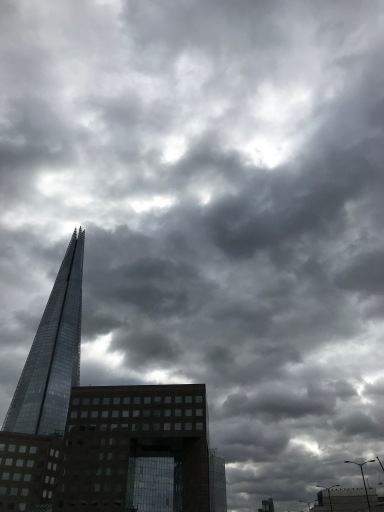
This part of the year will see it very much in the heart of the City. Views of the top of the Shard are rare enough between the buildings, let alone ones that happen to line up with the midday Sun. And so it proved – there was no clear shot of the Sun in the tip.
Fortunately my run had bought me some time so I walked (yes yes) around the streets trying to line it up. The Sun was too far left looking down Pudding Lane and too far right looking down Fish Street Hill, although the latter was closer, so the mark on the map attempts to guess where it would have been seen from.
Fish Street Hill leads down to the Monument, and at midday give or take a minute the Sun shines between the exceedingly narrow gap between the Monument itself and the building to the east. This was the closest I could photograph it, but a way to the west of where the alignment would have been.
Properly cut the head off that huh.
According to the excellent Know Your London blog, Fish Street Hill used to be the road leading north from the old London Bridge, and was busy with traffic, shops and shoppers. And fishmongers of course. The new London Bridge in 1831 robbed it of this prominence and the author now describes it as “Another boring street”. Well, if nothing else it’s got a good narrow midday Sun alignment. The Monument is to the Great Fire of London, in 1666, which started in the adjacent Pudding Lane. Between 2nd-6th September it burned more than 13,000 houses and displaced 70,000 people. No-one knows how many people died, but it was surely more than the six recorded. Apparently rumours of arson led to the lynchings of Dutch and French in the area. Thank god they didn’t have Twitter back then.
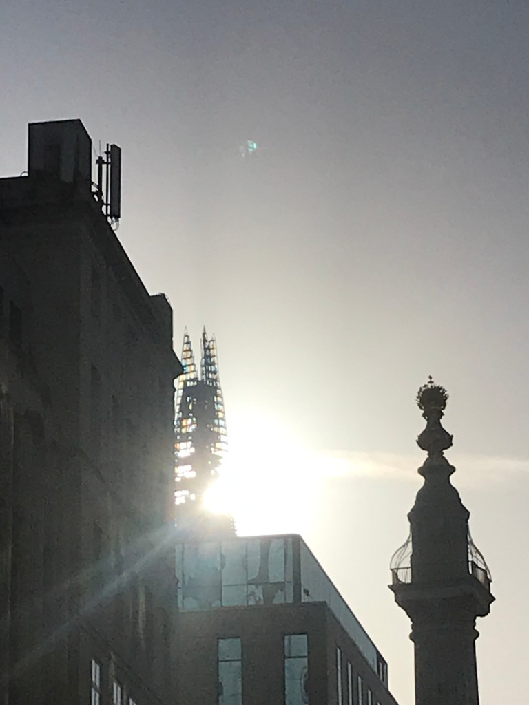
The next day though was a bit brighter, the cloud a bit higher and more transparent, and I arrived by the river to find the Sun much much lower than two and a half weeks previously. There’s no denying it changes quickly at this time of year.
So this was the first one on the north bank of the Thames. The north bank is riddled with tall buildings and twisting roads so this could be the last clear photo for a while. Even this was only possible because of an improbable and clearly unloved viewing platform high above the riverside path, and even then I was backed against the wall revealing the overhanging roof that crosses the top of the shot.
I’d been up here before to find nothing bar an empty vodka bottle, and this time it was rum. Nothing else. It’s a huge expanse, that whole red zigzag on Google Maps is just vacant flat terrace. Why is it not full of bars, seats, plants and skyline maps like the rest of the riverfront? Who owns it? Who maintains it and cleans up the bottles left by the few drinkers than know about it? Whoever, whatever, it’s the highest public bit of land in the area east of London Bridge, and without it I’d have been a good way further north. So I put the orange marker on the map vaguely norther too.
Curiosity piqued, I tried to find out who maintains this blank expanse. Looking at the map, it has Cubic London Bridge Office (Fireworks shop) and Sparkings Personnel (which doesn’t sound like a wise combination), along with Arachnys, Nova Financial Group and a couple of IFs. The building is called St Magnus House, so that’s a start.
St Magnus, like his over-the-river counterpart Olaf, was Norwegian. Unlike Olaf, he had a reputation for gentleness. He stayed on the ship and sang psalms rather than sack Anglesey, which can’t have gone down well with his fellow raiding Vikings, and he was eventually killed by a rival earl’s cook, while praying for the souls of his executioners. Not very much like Olaf at all, but there they stand commemorated facing each other across the river.
St Magnus House’s web page certainly lays claim to the terrace with a white line enclosing it:
But the website itself doesn’t mention it, perhaps as it’s public and not for sale. A regeneration proposal document on the City of London website does mention the terrace thus:
“The high-level terrace in front of St Magnus House is not clearly delineated as a public space and is underused, despite the fact that it affords some of the best views of the Thames.”
Indeed. It goes on to say:
“Possible improvements to increase footfall could include:
• Replacement of the existing staircase with a more open staircase leading directly from the Riverside Walk,
• Replacement of the high parapet walls with open railing/glass parapet, and
• Active frontage possibly including a café and roof garden to create an active space.”
Hard to argue with that. The full document is here:
Since it’s dated November 2014, and the terrace is still home to naught but the odd empty spirit bottle, it might be safe to say it was ignored. Apparently such terracing and high walkways were part of a plan to literally elevate the citizens of the City post-war. Some still remain, footbridges cross roads and doubtless more such terraces are tucked away, but like the November 2014 proposals, it seems the grand ideas fell on deaf ears. Shame.
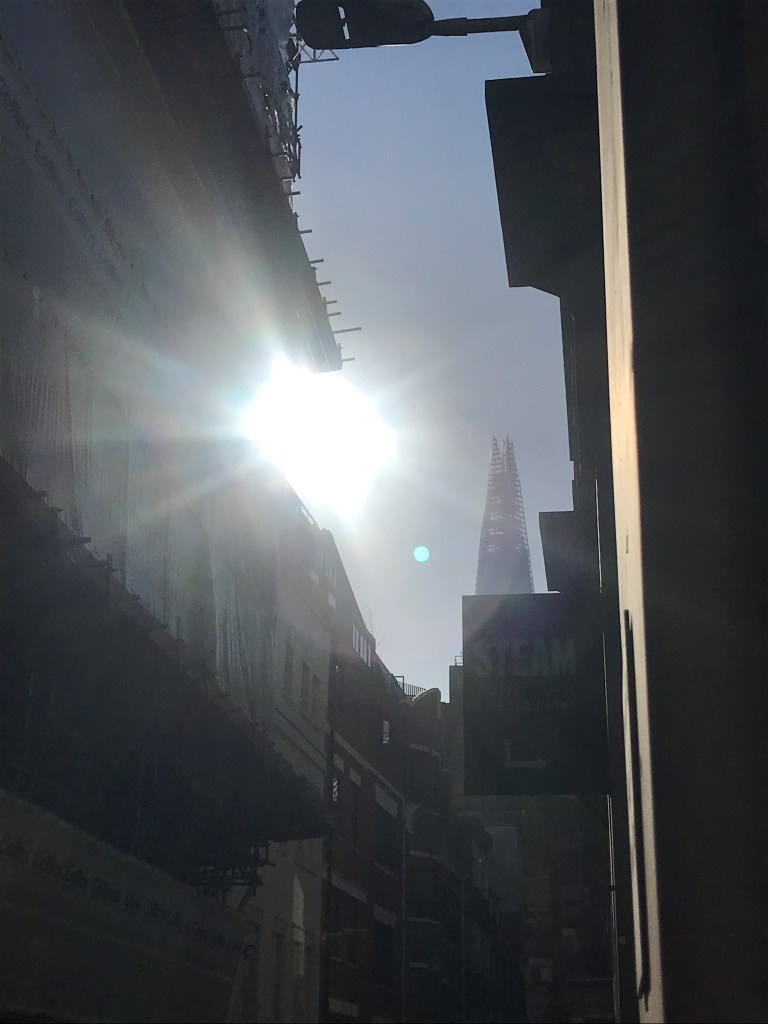
This was basically the inverse of the last one. I left the flat in bright sunshine, arrived in gathering gloom with the Sun obscured, got drenched in a downpour on the walk home, and arrived back at the flat in bright sunshine again. Well.
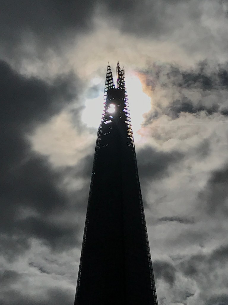
Even worse, there was a tease of a chance on the walk down. Four minutes earlier I glimpsed the disc of the Sun just below the tip through a gap in the cloud that quickly closed.
Handy of the building to have such a see-through tip, but four minutes is too much for a map tag.
This was last chance saloon for a while. The forecast for the rest of the week was dire, and then I was meant to be away for a few days. I woke to rain but the forecast said the cloud would break. I left the flat under heavy skies and tried to find value in the walk itself.
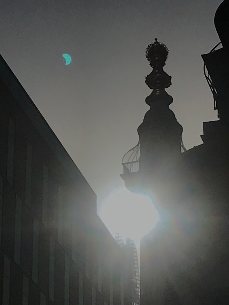
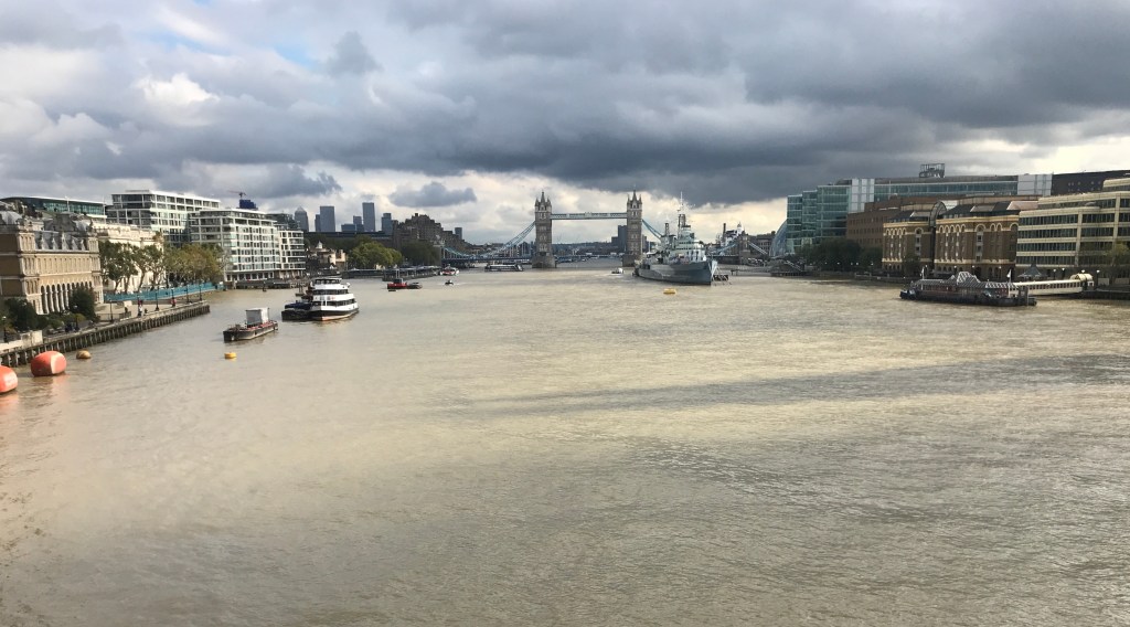
It was cloudy all the way. When I got to the river at the Tower I saw a wide patch of blue and hoped it wouldn’t repeat the tease of four days’ earlier. It didn’t. A small window of cloudlessness blew fast and clear straight over the Shard at one on the nose, stayed just long enough for me to try out newly-enabled GPS things and as much triangulation as I could muster, and was replaced a few minutes later by a low-lying slab of dark grey. You can see how close it was by the eastward-moving shadow below the Shard shadow here. This more than made up for 25th.
The shadow wasn’t yet on the north bank, although the rate it’s moving it won’t be long. It’ll be good to not have to attempt to triangulate positions from the Bridge for a bit.
London Bridge is an unlovely bridge, a slab of concrete on basic arches shown up entirely by the Victorian fantasy of Tower Bridge to the east. It’s part of London folklore that the old London Bridge was sold to an American businessman, Robert P McCulloch, after it was deemed no longer safe in the 1960s. He bought it for £1.7m and re-erected it in his new development at Lake Havasu City, Arizona. It was opened there in 1971 and had the desired effect of attracting tourists and house-buyers. Rumours that he thought he was buying Tower Bridge are entirely unfounded, by all accounts. Either way, the City of London rid themselves of a pretty dull bridge and replaced it with something just as dull. Unlike the old one, and recently Hammersmith Bridge, it does at least do the job of letting people and traffic cross the river safely.
This spot merits the first orange autumn tag on the map. There’s a long way to go from here before we start heading south again.
This shot is also the first one for which I’d turned on the photo location data. I downloaded an app called Exif which shows everything you could think of, including latitude and longitude. So this shot was taken from 51o 30’ 30.168” North and 0o 5’ 13.610” West. On the face of it that’s mighty specific and I had high hopes of it being spot on. As it turns out, however, Google Maps has this location firmly in the Thames. A quick test on a photo taken in my flat has the GPS location in a wholesale clothing shop on the main road nearby.
Bugger.
Looking at other photos from the same location, it seems there’s a bit of a spread on the GPS co-ordinates. Maybe looking at five or six and averaging them would get a bit more accuracy, but I’m not here to average GPS co-ordinates.
More useful, maybe, would be to count the lampposts on London Bridge, just faintly visible on the satellite/aerial imagery (which is quite something when you think about it). Looking at the supporting photos, the shot 22nd was from roughly level with the 6th, and this was from around the 4th.
From the north bank, the shadow looks like it’s coming out of the fetching Hays Wharf building, and Streetview does go down the esplanade facing it, so it should be possible to put three marks on the river from that, and GPS be damned. So the three marks in September are done like that, and if they look a bit off when and if the final figure 8 is done, you’ll know why. I’m going to have the same problem in six months’ time, of course. Maybe I’ll have a solution by then, or maybe I’ll be out there in a kayak dodging river buses and trying to line up a sunshot in the tides.
The first opportunity for an orange autumn tag came and went. I wasn’t planning on walking down this afternoon but I had errands to run so headed here on the off chance. No luck.
As a tease a tiny patch of blue drifted southeastwards approaching 1 o’clock, but it didn’t pass the Shard and it didn’t cast its shadow, so I had to make do with a pint and some sausages instead. There are worse consolations.
Of course by the time I headed back north over the bridge the Sun was bright and the shadow sharp, but I’m not going to be working out angles 48 minutes late. C’mon.